![](/images/other/stat-length.png)
![Tocht Stappen Le Châtelard - Croix du Plane - Photo](https://media.geolcdn.com/t/1900/400/d9e8fc9f-d43e-4dd2-9bef-b15b885e9f5d.jpg&format=pjpeg&maxdim=2)
Croix du Plane
ranchoup
Gebruiker
![Lengte](/images/other/stat-length.png)
![Max. hoogte](https://static1.geolcdn.com/siteimages/upload/files/1508320355ic_sort_altitude_max_24dp.png)
![Positief hoogteverschil](https://static1.geolcdn.com/siteimages/upload/files/1508320355ic_sort_den_pos_24dp.png)
![Km-Effort](/images/other/stat-length.png)
![Min. hoogte](https://static1.geolcdn.com/siteimages/upload/files/1508320355ic_sort_altitude_min_24dp.png)
![Negatief hoogteverschil](https://static1.geolcdn.com/siteimages/upload/files/1508320355ic_sort_den_neg_24dp.png)
![Boucle](https://static1.geolcdn.com/siteimages/upload/files/16400158638029165_repeat_loop_refresh_sync_direction_icon.png)
![Stappen](https://static1.geolcdn.com/sitytour/trail-icons/101.png)
5h09
Moeilijkheid : Gemakkelijk
![Scan deze QR-code om de tocht te openen in de SityTrail-applicatie](https://capi.geolives.com/qq0zvz2zws4bq2lad0pu/sitytour/trails/2771700/qr.png?size=200)
Gratisgps-wandelapplicatie
Over ons
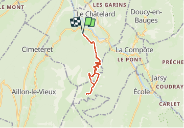
Tocht Stappen van 12,5 km beschikbaar op Auvergne-Rhône-Alpes, Savoie, Le Châtelard. Deze tocht wordt voorgesteld door ranchoup.
Beschrijving
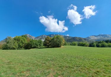
Belle rando de printemps.
Au départ de Montlardier, prendre la route forestière sur un peu plus de 3 km : belle partie en forêt pour s'échauffer en pente douce.
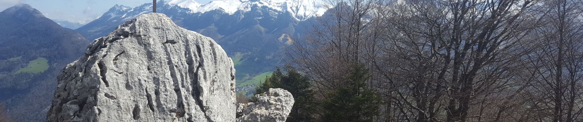
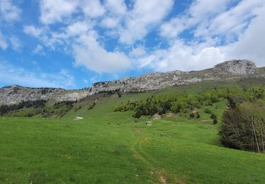
Suivre ensuite le sentier (marque jaune et vert) qui monte de façon plus soutenue jusqu'à la Croix du Plane. Beau panorama, ça vaut le coup de monter encore en suivant le chemin d'alpage jusqu'à Sur l'Arpette, pour découvrir tout le panorama .
A la redescente, on peut aller voir le joli chalet d'alpage Chaffard.
Plaatsbepaling
Opmerkingen
Wandeltochten in de omgeving
![Tocht Stappen Arith - La Montagne de Bange 1434m, depuis Montagny - Photo](https://media.geolcdn.com/t/375/260/ext.jpg?maxdim=2&url=https%3A%2F%2Fservices.sitytrail.com%2FGeolivesWS%2FDownloadMedia.ashx%3FTrailID%3D317290%26Media%3D16482_1.jpg)
![Stappen Stappen](https://static1.geolcdn.com/sitytour/trail-icons/101.png)
Stappen
![](/images/other/stat-length.png)
![](https://static1.geolcdn.com/siteimages/upload/files/16400158638029165_repeat_loop_refresh_sync_direction_icon.png)
![Tocht Stappen Doucy-en-Bauges - Traversée du Mont Trélod, 2181m - Photo](https://media.geolcdn.com/t/375/260/ext.jpg?maxdim=2&url=https%3A%2F%2Fservices.sitytrail.com%2FGeolivesWS%2FDownloadMedia.ashx%3FTrailID%3D103833%26Media%3D6623_1.jpg)
![Stappen Stappen](https://static1.geolcdn.com/sitytour/trail-icons/101.png)
Stappen
![](/images/other/stat-length.png)
![](https://static1.geolcdn.com/siteimages/upload/files/16400158638029165_repeat_loop_refresh_sync_direction_icon.png)
![Tocht Ski randonnée Le Châtelard - col de Rossanaz - Photo](https://media.geolcdn.com/t/375/260/50e32d24-befc-4efc-87ab-b6a2311f6d3b.jpg&format=jpg&maxdim=2)
![Ski randonnée Ski randonnée](https://static1.geolcdn.com/sitytour/trail-icons/503.png)
Ski randonnée
![](/images/other/stat-length.png)
![](https://static1.geolcdn.com/siteimages/upload/files/16400158638029165_repeat_loop_refresh_sync_direction_icon.png)
![Tocht Stappen Le Châtelard - Roc poyet - Photo](https://media.geolcdn.com/t/375/260/a503fd55-09ac-42bc-9003-547472a05706.jpg&format=jpg&maxdim=2)
![Stappen Stappen](https://static1.geolcdn.com/sitytour/trail-icons/101.png)
Stappen
![](/images/other/stat-length.png)
![](https://static1.geolcdn.com/siteimages/upload/files/16400158638029165_repeat_loop_refresh_sync_direction_icon.png)
![Tocht Stappen Doucy-en-Bauges - 2015-09-11 Marche Mont Trelod - Photo](https://media.geolcdn.com/t/375/260/ext.jpg?maxdim=2&url=https%3A%2F%2Fstatic1.geolcdn.com%2Fsiteimages%2Fupload%2Ffiles%2F1553511878bg_sport_marche.png)
![Stappen Stappen](https://static1.geolcdn.com/sitytour/trail-icons/101.png)
Stappen
![](/images/other/stat-length.png)
![](https://static1.geolcdn.com/siteimages/upload/files/16400158638029165_repeat_loop_refresh_sync_direction_icon.png)
![Tocht Stappen Jarsy - nôtre dame de Bellevaux - Photo](https://media.geolcdn.com/t/375/260/1be31ea5-d3d1-459b-88d3-6aa2e29612aa.jpg&format=jpg&maxdim=2)
![Stappen Stappen](https://static1.geolcdn.com/sitytour/trail-icons/101.png)
Stappen
![](/images/other/stat-length.png)
![](https://static1.geolcdn.com/siteimages/upload/files/16400158638029165_repeat_loop_refresh_sync_direction_icon.png)
![Tocht Stappen Doucy-en-Bauges - 250524 Le Trelod et la Dents des Portes - Photo](https://media.geolcdn.com/t/375/260/4afdb455-3922-47f1-8f79-e9d92dd0333d.jpg&format=jpg&maxdim=2)
![Stappen Stappen](https://static1.geolcdn.com/sitytour/trail-icons/101.png)
Stappen
![](/images/other/stat-length.png)
![](https://static1.geolcdn.com/siteimages/upload/files/16400158638029165_repeat_loop_refresh_sync_direction_icon.png)
![Stappen Stappen](https://static1.geolcdn.com/sitytour/trail-icons/101.png)
Stappen
![](/images/other/stat-length.png)
![](https://static1.geolcdn.com/siteimages/upload/files/16400158638029165_repeat_loop_refresh_sync_direction_icon.png)
![Tocht Stappen Aillon-le-Vieux - col colombier - Photo](https://media.geolcdn.com/t/375/260/e2b5f89d-50b0-4b1d-ae97-04fc8e08fc45.jpg&format=jpg&maxdim=2)
![Stappen Stappen](https://static1.geolcdn.com/sitytour/trail-icons/101.png)
Stappen
![](/images/other/stat-length.png)
![](https://static1.geolcdn.com/siteimages/upload/files/16400158638029165_repeat_loop_refresh_sync_direction_icon.png)